Proud of your support of the RMC? Want to let everyone know? This is your page!
Your purchases directly support RMC’s work on trails, camps and in the club community. Why not consider an RMC gift for a friend or relative– and benefit the club’s efforts at the same time?
The RMC uses PayPal for all online purchases; we are unable to accept phone orders or mailed orders. Because fulfillment of orders is handled by volunteers, please allow one to two weeks for delivery.
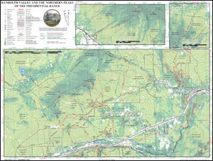
Randolph Valley and Northern Peaks of the Presidential Range Trail Map (2016)
While the map includes the guidebook's updates to trails, land ownership and other geographic information, more noticeable is its overall redesign, in comparison to the editions of 2005 and 1996. The area traditionally shown on the RMC map has been divided in two, with the "Hill" side (the town of Randolph and the Crescent Range) on one side of the sheet, and the "Mountain" side (Mts. Madison, Adams and Jefferson) on the other. The Randolph Valley, with the trailheads along Durand Road and U.S. Route 2, appears on both sides.
Since the map sheet is the same size as the previous editions, the two-sided map is printed at a larger scale and with a smaller contour interval, and displays denser sections of the trail network with more accuracy and higher resolution. Also for the first time, the map uses color to indicate types of forest areas, with a darker green for conifers and a lighter green for deciduous trees; note that this is completely different from the conventional use of graduated colors to indicate changing elevation. This forest-type overlay significantly increases the amount of information on the map compared to the 2005 edition (which differentiated between forest and non-forest only) and the 1996 edition (which had no such information at all).
Updates to man-made features within the map area include the Randolph Community Forest Trailhead and the RMC's associated new trails and trail changes, the Community Forest's new interpretive trail current boundaries and logging roads, other protected land areas abutting the RCF and WMNF, the bike trails in Moose Brook State Park, the route of the overhead power lines south of Route 2, and seasonal-use information about the Presidential Rail Trail.
The RMC thanks Jonathan Hall for the many hours he has put into designing and creating the new map. We are grateful also for the collaboration and assistance of Doug Mayer, Jim Anderson, Dwight Bradley, Jamie Maddock, Carl Herz, and Judy Hudson.
Printed on: Tyvek paper
Scale = 1:20,000Contour Interval = 50 feetDimensions of map = 24" x 18"


